
Location: Eastern Africa, just south of Equator; (Longitude between 29 degrees and 41 degress East of Greenwich, Latitude 1 degrees and 12 degrees South of Equator);
Bordering Uganda and Kenya in the north; Democratic Republic of Congo, Burundi and Rwanda in the west; Zambia, Malawi and Mozambique in the south and Indian Ocean to the east;
Altitude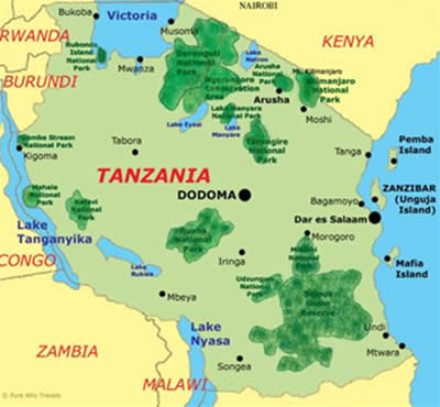
- Central plateau: from around 1200m above sea level (metric converter);
- Highest point: Mt. Kilimanjaro (5895m);
- Lowest point: Lake Tanganyika (358m below sea level);
Landscape
- Central mainland consists of a central plateau covered with huge expanse of savannah and sparse woodland;
- Throughout the interior runs the Great Rift Valley which has created many fascinating topographical features such as the Ngorongoro Crater and Lake Tanganyika;
- Mountain ranges are grouped on the north-eastern section (the Eastern Arc), and a central and southern section (the Southern Arc);
- Coastal area: 1400km long, blossoming and palm-fringed with islands of Zanzibar (Unguja Island), Pemba and Mafia;
- Largest river: Rufiji;
- Major lakes: Lake Victoria, Lake Tanganyika, Lake Nyasa (Malawi);
Climate
Tropical, with the average temperature in the coastal area from 26–31 degrees Celsius with hot days cooled by sea breezes (metric converter) and in central plateau from 20-27 degrees Celsius with hot days and cool nights.
There are two rainy seasons: longer (masika) from mid-March to May, and short (vuli) in November. The hottest months are from October to February.
Population
36 million people with 51% of women and 46% under age 15. The national growth rate is 1.72%.
Life expectancy at birth is 44.5 years (male 43.3 years, female 45.8 years).
Tribes
There are more than 130 tribes; the Most widespread include Sukuma, Nyamwezi, Makonde, Haya, Chagga; smaller ones include Maasai, Haadzabe. There is also an important Asian and Arabic population.
Capital
Dodoma (administravtive capital).
Other Major Cities
Dar es Salaam (business capital), Mwanza, Mbeya, Arusha, Bukoba etc.;
Language
Official languages are Swahili and English; tribes also speak their own languages.
Literacy
78% of the total population aged 15 years and over can read and write Swahili (Kiswahili), English or Arabic.
Religion
- Christian: 40-45%;
- Muslim: 35-40%;
- Hindus, Sikhs, indigenous beliefs etc. 15-25%;
- Zanzibar: 99% Muslim;
Currency
Tanzanian Shiling (TZS), which is divided into 100 cents. Paper notes: 10.000, 5.000, 2.000, 1.000 and 500; Coins: 200, 100, 50, 20, 10, 5 and 1.
Government
Multiparty Democracy with CCM (Chama Cha Mapinduzi; Party of the Revolution) as a current Ruling Party.
National Flag
Black for the People, Green for the Land, Blue for the Adjoining Sea and Golden for the Mineral wealth.
Time Zone
GMT + 3 hours with no daylight saving.
International Dialing Code
- County Telephone Code: +255;
- International Exit Code: 00;
Internet Domain
.tz
Electricity & Plugs
230 V, 50 cycles, AC; in general the plugs are British three-square-pin and two-round-pin. Adapters are available.
National Resources
- Minerals: gold, diamonds, tanzanite and other gemstones, nickel, iron, coal, natural gas, spring water, soda ash, salt;
- Wildlife and Tourism: 12 National Parks, the Ngorongoro Conservation Area, 13 Game Reserves, 38 Game Controlled Areas, about 120 National Cultural Heritage Sites;
- Fisheries: in three large lakes (Lake Victoria, Lake Tanganyika, Lake Nyasa), Indian Ocean coastline, rivers and wetlands the potential yield of fish is estimated to be 730.000 tons annually (present catch is 350.000 tons annually);
- Forestry and Beekeeping: non-reserved forest-land (1,903.8 sq km), forest/woodlands with national parks etc. (200 sq km), and gazetted forest reserves (1,251.7 sq km).
GDP
270 US$ per capita.
Major Exports
- Agriculture: Coffee, tea, cotton, cashew, sisal, cloves;
- Minerals: gold, diamonds, tanzanite and other gemstones, nickel, iron, coal.
Distances
Tanzania is a large country and distances between cities or national parks can be lengthy (metric converter). Distances shown are in km.